
Information about the Evelyn Fault has always been hard to find. In The Dandenong Volcano, John Lundy-Clarke described the structure of the Mt Dandenong volcanic caldera:
The lava cauldron was in the shape of a squashed triangle, the western edge running from Mt Evelyn through Montrose to Ferntree Gully. It was bounded on the south by the Selby Fault (which stretches from Ferntree Gully to near Emerald) and in the east by another fracture in the earth’s crust, the Evelyn Fault which passes close to Monbulk. ...
When the final series of eruptions had emptied the cauldron of gases and lava the platform of earlier lava was too weak to carry the weight. It fractured along both the Evelyn and Selby Faults and also across the middle, thus leading to the subsidence of the whole mass of lavas plugging the cauldron. 1
Lundy-Clarke provides a map of the successive lava flows but does not include the fault lines. A 1973 hand-drawn map of his in the Yarra Ranges Regional Museum, 'Souvenir of Visit to Harmony Vale', illustrates 'how the terrain affected by the Evelyn Fault was utilised by the pioneers of Harmony Vale' (an early settlement in Kalorama). The map shows the Fault, but not in relation to Mt Evelyn. 2
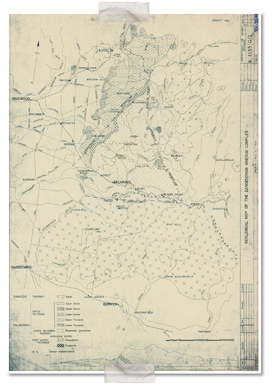
A 'Geological Map of the Dandenongs Igneous Complex' in the State Library finally shed some light on the problem. This map shows the Evelyn Fault running south from Evelyn (Mt Evelyn) township, west of Olinda Creek, to the Silvan area, where it meets the Monbulk Monocline. The other two features that define the edges of the caldera appear here as the Selby and Montrose Monoclines. 3
The monoclines were named after townships (Monbulk, Montrose, Selby), reflecting their locations. So it seems likely that the Evelyn Fault was named after the township, not the County of Evelyn. The township has also given its name to a type of rock originating from the volcano, the Mt Evelyn Rhyodacite.